Installing your own Points Of Interest (POIs) on TomTom car GPS using Google Maps and PoiEdit

I have got a TomTom Go 630 car GPS navigation unit. This summer I have been looking in to how I could load my TomTom with a number of POIs (Points of Interest) before going off for our three weeks in sunny France.
I will document what I have found out. I think that my method could be useful to others.
What You will have at the end is a new category available in your TomTom device. Just like you have a category for Restaurants, you can have your own. Mine is called Summer2010.
The category will contain the POIs that you have found in Google Maps.
Create a map of your POIs using Google Maps
First I logged in to Google Maps at http://maps.google.com.
Then I used the My Maps feature to prepare my own map for my summer holidays. Basically what you can do is to create your own set of location-markers that are shown on top of Google Maps.
In my example I saved the locations of the European Disneyland and Parc Astérix:
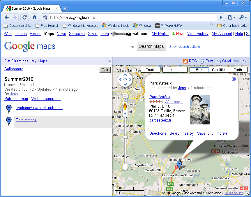
If you are not familiar with the My Maps feature, you will need to play a bit with it. It's really cool. I have for instance created a map that I send to people that are visiting my local area as tourists; a map of restaurants, sights, shopping centres and the like.
When You have prepared a Google map with the Points you would like to see show up in your own TomTom category, you export the map to a file with the extension kml. This is, as far as I know, unsupported...
You do the exporting like this.
Click the "Link" link (in the rightmost part of the page,just above the actual map).
Now you are presented with two URLs. Copy the first URL, the one called "Paste link in email or IM".
paste that URL in your browser and append this to the end of the url: &output=kml.
Activate the URL and your browser will download the file as mapname.kml, where map name is based on what you called the map in Google Maps.
How to create an ov2 file
Now you want to create the POI file that can be transferred to the TomTom device. What you need is to create two files called category.something.They both need to have the same name but different file types. In my example
summer2010.bmp. A BMP file that is exactly 22x22 pixels. This bitmap will be displayed on the device when you work with your POIs.
summer2010.ov2. An ov2 file. This file contains the location names and coordinates.
How to create a 22 by 22 bitmap is up to you. I will not go into that. Google the subject if you do not know how to create your own.
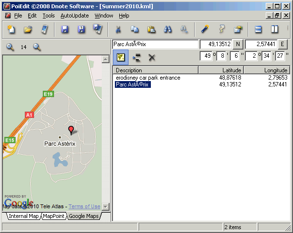
I use a freeware piece of software called POIedit 2007 for creating the OV2 file. Its downloadable from http://www.poiedit.com/ - download link is on the left hand side menu on that website.
Download and install. I recommend using the default settings. Note that during the installation you are asked which files will be associated with POIedit and one of those file types is kml. That is the format in which we saved the file we got from Google Maps.
Fire up POIEdit. And shut it down again.
Now find the summer2010.kml file you downloaded from Google Maps. Double-click it. POIEdit will load it for you.
If you click one of the location names on the right you will see the map location on the left.
We're close now.
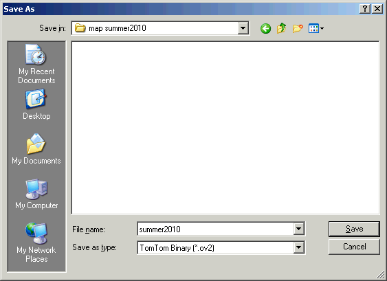
Save the project using File->Save As
Make sure you save as a TomTom Binary (*.ov2) like this:
Copying your POI category to the TomTom car GPS
Now you have two files that make up the new POI category:
summer2010.bmp
summer2010.ov2
Next you need to copy those two to your TomTom device.
Plug the TomTom device in to your PC. Wait for the PC to register the device as an external drive.
Then browse the TomTom folders. You need to find a folder, probably just off the root folder. It is a folder that will be named after the map set that came with your device. Mine is called "Western Europe", so the folder is "G:\Western Europe".
I know that it could also be called for instance "G:\Great britain".
Copy the two files you create to that folder. Yes - dump it in to the folder that contains the map you bought with the TomTom.
That's it. Make sure you close the USB-connection to the device properly. Right-click the Sytem Tray icon called
Safely remove hardware, select whatever is appropriate, find your tom tom and tell it to Stop. This makes sure that your files are saved properly before you unplug.
Turn off the device and then on again. Your new category should now be available from the list of POIs.
Sources of information
How to output Google Maps to KML files: How to export Google Maps' MyMaps data in full?
POIedit - software for editing and saving to TomTom and other POI file-formats: http://www.poiedit.com/
Information about what is required for a TomTom POI fileset: Creating POIs
How to transfer the TomTom POI file (file set really) to the TomTom device: HOW TO INSTALL POI's